
In 1847, a charter was granted to the Swan Point Cemetery Company, a stock company under the management of a board of trustees. A reorganization was effected in 1858 under a new charter, creating a nonprofit corporation entitled, “The Proprietors of Swan Point Cemetery.” Bylaws were adopted, providing for the election by the corporation of six directors. The board was authorized to appoint a chairman, a secretary, a treasurer and a superintendent of the grounds.

From time to time, the cemetery acquired additional land between The Neck Road and the river, and in 1862 began its expansion to the west by purchasing farms and other properties, extending the estate to Hope Street.
A chronicle of the past takes shape
Among the earlier purchasers of land in the cemetery was the First Congregational Society (now First Unitarian Church), which acquired an oval tract of five acres. To that spot were transferred the remains interred in a portion of the West Burial Ground which had been owned by that society since 1785 and which included remains from an earlier burying place established in 1722. The West Burial Ground was a group of private cemeteries, now vacated, occupying a part of the area bounded by Friendship, Plain, and Lockwood Streets. Three of those cemeteries, the Union, Hope and Manchester grounds, were acquired by Swan Point Cemetery, and the interred remains were removed to its grounds between 1859 and 1882.
In the early years of the cemetery, the highway pattern of the upper East Side had not yet become established, and the grounds were reached by way of a road that zigzagged from North Main Street over Olney Street, Morris Avenue, Sessions Street, Cole Avenue and Rochambeau Avenue and continued to Pawtucket as the Neck Road. The first means of public conveyance to the grounds was an omnibus that followed that route in the early 1870’s. A few years later, the Governor Street horse car line was extended to Wayland Square and from its terminus, an omnibus provided transportation over Angell Street and Butler Avenue, the latter being merely a country road at the time.
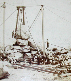 In order to provide better means of access to the expanded grounds of Swan Point, the directors, in 1886, engaged in the services of H.W.S. Cleveland, a landscape architect of Chicago, Illinois, who planned the layout of Blackstone Boulevard. Prior to its construction in 1894, Swan Point Cemetery deeded to the city a strip 200 feet wide through its estate. Using boulders excavated from the estate, a boulder wall was erected along the east side of the boulevard, bounding the cemetery grounds, and a new entrance was established. The Butler Avenue trolley line was extended over Blackstone Boulevard to the cemetery in 1903, and a fieldstone shelter was erected at its terminus opposite the cemetery entrance.
The extension of Blackstone Boulevard through the cemetery grounds left about 22 acres west of the boulevard so isolated from the remainder of the grounds it was deemed unsuitable for burial purposes. After 20 years of disuse, part of the land was developed as a general working plant for the cemetery.
 A greenhouse was built in 1917, a superintendent’s house in 1923, and a group of service buildings in 1932. Two parcels of land were deeded to the city in 1933 providing, respectively, for the extension of Lorimer Avenue from its intersection with Eighth Street to the boulevard, and for the establishment of Alexander Farnum Lippitt Memorial Park at the junction of Hope Street and the boulevard. Beginning in 1946, other sections of land were developed into house lots, which subsequently were sold and houses were erected upon them. With the sale of the superintendent’s house in 1959, the land remaining in the cemetery’s possession west of the boulevard was reduced to about six acres.
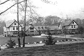
The last of the land owned by the cemetery west of the boulevard was sold and has since been privately developed into an attractive residential area. Immediately prior to disposing of this land, a modern service-building complex, including a greenhouse, was erected at the southerly end of The Old Road. Extending from Blackstone Boulevard to the Pawtucket line, The Old Road was abandoned by the city as a public highway in 1933 and reverted to the abutting owners, Swan Point Cemetery and Butler Hospital. The hospital subsequently conveyed its interest in the road to the cemetery.